
On January 14, the US Department of Transportation (DOT) released a milestone study on GPS alternatives. A key marker in the push for more secure, reliable, and resilient PNT technologies, the report is a natural complement to Executive Order 13905, which set the parameters for scientific and policy inquiry.
The DOT report is designed around a simple premise. The immense value of the Global Positioning System (GPS) to the world economy is starting to look like overreliance on a single vulnerable, aging technology. While GPS will continue to play a central role in PNT services, it makes sense for governments around the world to invest in technologies which can supplement and augment the vital capabilities of GPS.
The demonstration of technologies for Position, Navigation, and Timing (PNT) was produced jointly with the Departments of Defense and Homeland Security. The report covers demonstration planning, outlines the government reference system used to collect and verify results, and creates a framework for measures of effectiveness.
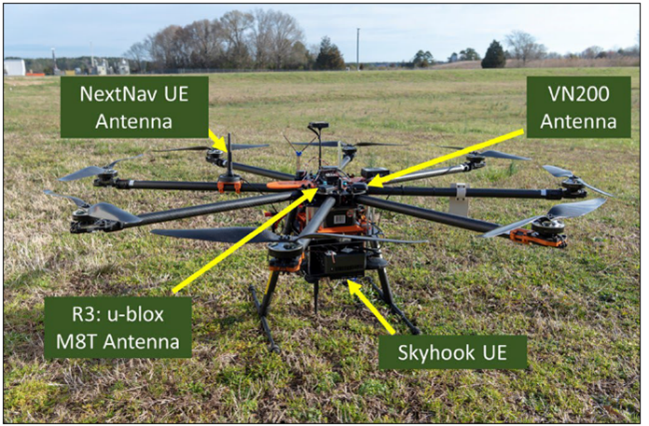
To assess the options for resilient PNT, DOT tested eleven different solutions in a series of rigorous field trials at Joint Base Cape Cod and the NASA Langley Research Center. The diverse group of technologies included multiple approaches to delivering PNT, including both satellite and ground-based, terrestrial solutions.
We’re clearly thrilled that NextNav ranked as the top performing solution in every Position, Navigation, and Timing scenario tested by DOT.
A close read of the report also uncovered several key insights which also deserve mentioning:
Many GPS alternative solutions only address specific use cases.
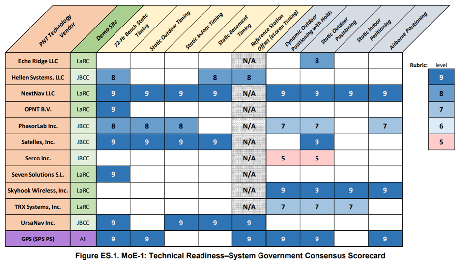
NextNav was the only solution in the DOT test which addressed every use case for position, navigation, and timing. It was particularly telling that only NextNav functioned in all indoor and outdoor PNT scenarios, including airborne 3D positioning and static basement timing. Even GPS can’t deliver reliable position and timing indoors.
To paraphrase one of the four key findings from the report (Page 194), “all vendors demonstrated some PNT performance of value, but only one vendor, NextNav, demonstrated in all applicable use case scenarios.”
Not all GPS alternative solutions are market ready.
It’s worth noting that of the twenty-one companies which submitted responses to the DOT RFI, only eleven were chosen to demonstrate their technologies in field tests. The DOT study evaluated the state of market readiness for each solution, based on the Technology Readiness Level (TRL) used by US government agencies. NextNav rated the top level (TRL 9), meaning that it is proven in an operational environment and ready for large deployments.
This only confirms that there are many technological options to supplement existing PNT capabilities, but few which are deployable in the near term. NextNav’s TerraPoiNT technology has the advantage of being used in the field for several years.
It also affirms the position of the Open PNT Industry Alliance, which advocates for a multi-technology approach to GPS alternative technologies. Since many of the solutions in the DOT test only addressed one of the three PNT elements, building a robust and competitive marketplace will require the use of many solutions concurrently.
Or, in the report’s own language: “The findings indicate that the best strategy for achieving resilient PNT service is to pursue multiple technologies to promote diversity in the PNT functions that support transportation and other critical infrastructure sectors.”
Some GPS alternatives require additional user hardware.
GPS has a singular advantage over just about every alternative PNT solution out there: it’s already integrated into our phones, devices, and IoT sensors.
It’s one thing to deploy a signal network for PNT, but quite another thing to build or integrate receivers for those signals across a mass base of users. This is why DOT looked not only at the TRL for signal delivery, but also for user equipment. The results are instructive – NextNav was one of the few solutions which boasted the top TRL of nine in both categories.
Many alternative PNT solutions rely on GPS.
One of the main reasons DOT tested alternative PNT solutions is that we’re already over-reliant on GPS satellites. We already know that GPS spoofing is a problem, and jamming the signal is easier than you might think. Technical glitches cause minor disruptions in GPS signal availability all the time. DOT is looking for solutions which can produce reliable results even if signals from the Global Navigation Satellite System (GNSS, of which GPS is a part) are unavailable.
In this context, it’s surprising that quite a few of the solutions DOT tested rely on GPS to provide one or more of the PNT elements. NextNav was one of the few services which operate on a completely independent basis. If GPS is unavailable, those other solutions are going to find it difficult or impossible to deliver essential services. This again points to the need for a multi-technology approach to APNT – one that can build a range of services which are truly independent of GPS.
Some GPS alternatives don’t play well with GPS.
While the ability to operate independently of GPS is a good thing, lack of interoperability with GPS can be a problem. Since most of our location infrastructure is built around the technical specifications of GPS, straying too far away from the norm can make technologies harder to deploy and adopt at a mass level.
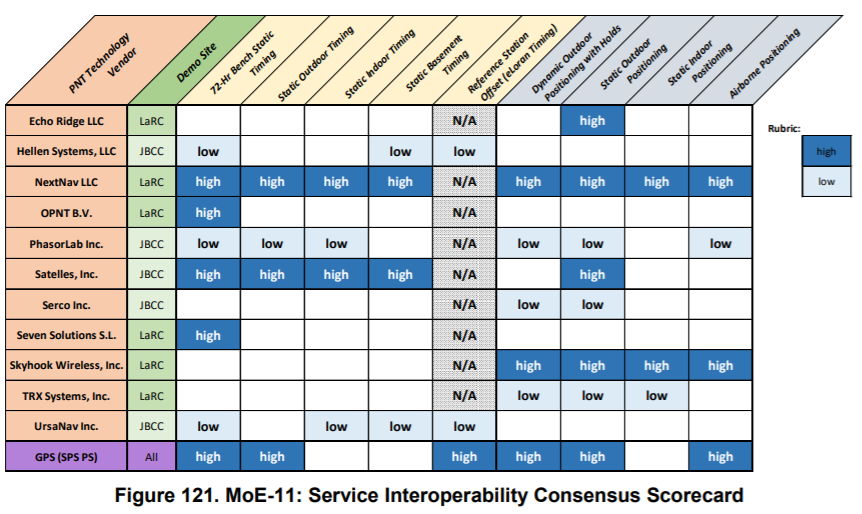
NextNav’s TerraPoiNT system has a critical advantage here. The waveforms used by our dedicated spectrum in the United States are very similar to those of GPS, and easily translated into mass market devices which are used by consumers every day. That’s why DOT gave us a perfect score for system interoperability in every category.
Complementary PNT solutions need to be resilient
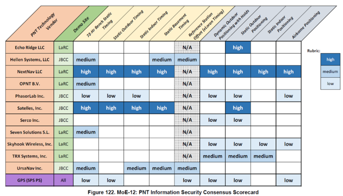
To offer meaningful security and resilience, any PNT solution must take intentional disruption or manipulation into account. This means robust signal encryption and authentication, plus a way to authenticate user equipment. As noted in the DOT report, resilience is at the heart of NextNav’s TerraPoiNT system.
Additional countries are investigating GPS alternatives.
The DOT report is one of many similar documents produced by countries around the world. Late last year, the European Union released an RFI for alternative PNT solutions, which it plans to test at an Italian facility in 2021.
Here at NextNav, we’re pretty excited about these tests and reports. They affirm what we’ve been saying all along – that the security vulnerabilities and operational limitations of GPS require some immediate attention. We’re already focusing on how all of the data produced by these reports will translate into action, and in helping government agencies craft a viable path forward.
Learn more about TerraPoiNT, NextNav’s solution for resilient PNT.