This year’s IWCE returned to Las Vegas, kicking off with in-depth sessions, briefings, technology discussions, and case studies—each vital to wireless communications in mission-critical environments.
On Day 1, the NextNav team was honored to lead a panel on a timely and essential topic: “GPS Vulnerabilities – A Cybersecurity Risk for Public Safety Operations.” Moderated by Ed Mortimer, Vice President of Government Affairs, the session explored current challenges, the need for resiliency, and complementary backups to GPS. Ed also emphasized what public safety agencies can do to stay informed about the leadership role the FCC has taken on this critical issue. The session resonated strongly with attendees and became a recurring theme seen throughout the first two days, especially in discussions centered around location accuracy across the x, y, and z axes.
Following that session, NextNav joined Bob Escalle (Siyata Mobile), Josh Lober (ESChat), and Kelly Moore (Santa Barbara Unified School District) to discuss “Safeguarding Campuses with Critical Voice and Emergency Messaging with Location Services.” We covered operational and technical aspects of campus safety. NextNav’s location expertise was key to this conversation, as we explored not only how precision indoor location becomes vital during emergencies but also how proactive use of x, y, and z-axis intelligence supports everyday student and faculty operations.
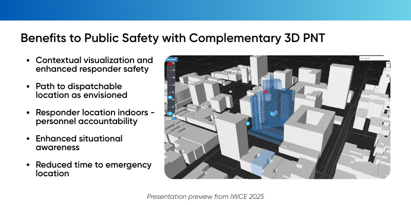
Beyond panels, IWCE fostered valuable conversations and impromptu meetups, one of the event’s most powerful aspects. The spirit of collaboration was alive and well. Tuesday featured several highlights, beginning with a panel I co-hosted alongside Patrick O’Connor, co-founder and President of 3AM Innovations, a NextNav integration partner. Together, we presented “Vertical Location Testing in Washington, DC – Phase 1 and 2 Results.” We shared results from one of the most comprehensive real-world tests to date on the use of z-axis data and its potential for operational use in public safety. Led by Arlington County Fire and Emergency Communications, with support from Washington DC Fire and the Office of Emergency Management and Homeland Security, the year-long initiative proved that z-axis data is not only valuable—it becomes actionable when delivered in Height Above Ground format and visualized in a 3D viewer.
Next in the line up was, “Emerging Tech in the Fire Service,” a powerful conversation featuring Chiefs Dan Munsey (San Bernardino Fire Department), John Butler (Fairfax County Fire & Rescue), and Daniel Sheridan (FDNY). When asked about the most critical technologies they rely on, all three pointed to location accuracy. Chief Butler responded, “x, y, and z location.” Chief Munsey added, “The z-axis from NextNav and the work they’ve done with 3AM Innovations to bring this to the fire service.” Chief Sheridan called it “The Holy Grail. That’s what matters most to us. The z-axis is the Holy Grail.” Hearing this firsthand was humbling and reaffirmed that resilient location tech and GPS backups are not optional—they’re essential.
The final session of the day provided a fitting close: “State Efforts to Establish Terrestrial GPS Backup Systems.” Led by Walt Magnussen of Texas A&M University’s ITEC, this panel highlighted the growing need for resilient PNT systems and state-led initiatives providing terrestrial alternatives. As emphasized during the panel, GPS vulnerabilities pose a national security risk and a threat to the resilience of critical communications infrastructure. Public safety leaders must make their voices heard in the newly approved FCC Notice of Inquiry, Docket Number 25-110.
A huge thank you to IWCE for once again bringing together the brightest minds in mission-critical communications. Progress is a team effort, and as location truly matters more than ever, now is the time to raise your voice and take action for public safety.