
NextNav is working to revolutionize the way we experience location-based services, by enabling developers to easily integrate 3D visualization capabilities to their application. NextNav provides highly accurate altitude information to add to the latitude and longitude coordinates from devices enabling developers to create immersive visualizations with 3D building data.
Applications for 3D Visualization
There are numerous applications where 3D visualization can be useful, but arguably none more so than in emergency services. In 2022, the United States’ Federal Communications Commission required that all commercial mobile radio service (CMRS) providers deliver the z-axis coordinates of emergency calls to each Public Safety Access Point (PSAP). While CMRS providers traditionally deliver emergency call x- and y-axis coordinates to help PSAPs locate the address of 911 callers, response crews often struggle to locate callers in multistory buildings.
As part of an effort to empower emergency responders to reach people in need more efficiently, the FCC requirement ensures that CMRS providers deliver z-axis call coordinates to PSAPs. However, without a 3D mapping and visualization solution, PSAPs and emergency response teams are limited by the necessary context to make use of the z-axis coordinates. A 3D visualization solution would enable first responders to visualize mission critical situations in 3D and locate where in a building an emergency call is coming from or the location of first responders relative to each other, as pictured below:
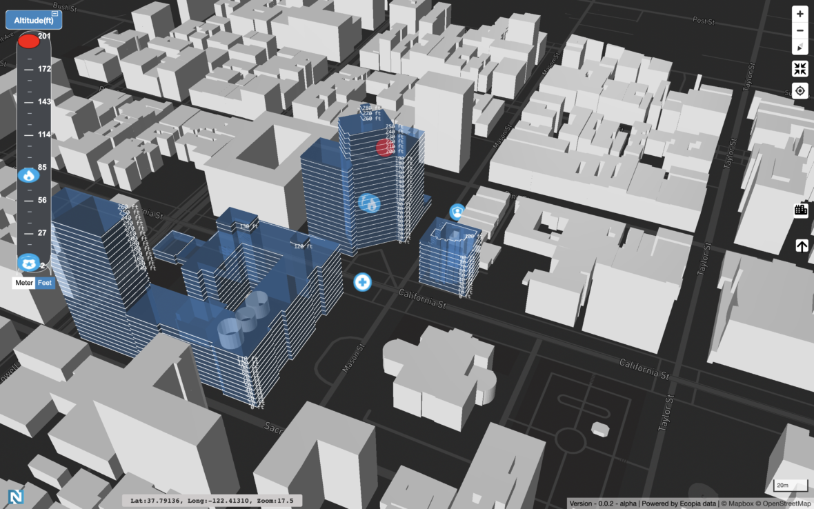
3D visualization is an essential technology that is helping public safety agencies to better respond to emergencies and ensure the safety of the general public. It provides a real-time view of the environment, enabling agencies to quickly identify potential threats and respond accordingly. It also allows for efficient resource management, effective incident response, and improved communication among different agencies.
Understanding NextNav’s Pinnacle Geolocation Technology
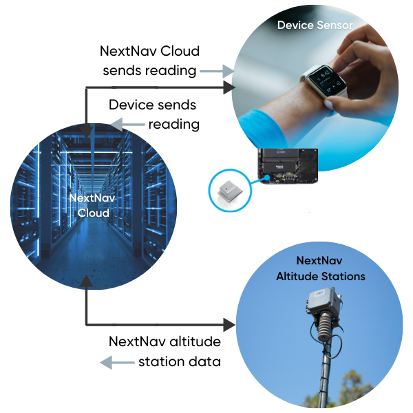
How does this all work? NextNav uses a combination barometric pressure data, network infrastructure, and a cloud service to provide highly accurate vertical positioning information in real time.
While GPS can provide accurate horizontal positioning information, it struggles with altitude, especially in urban environments where buildings can block satellite signals. NextNav’s Pinnacle technology uses barometric pressure sensors already in smartphones and other devices to calculate altitude. The Pinnacle service compares device data to local conditions from altitude stations, subtracting the weather and other factors to leave behind a highly accurate altitude measurement – according to independent testing, providing floor-level accuracy 94% of the time.
NextNav continues to work with partners to create immersive and highly accurate location-based applications. If you’re looking to learn more about NextNav’s groundbreaking technology or have an application that could utilize 3D visualization, contact us to request access to NextNav solutions and begin testing. So what can you create with NextNav’s geolocation capabilities? The possibilities for innovation are endless.